Topic:
AirNav Radar Introduction
AirNav Radar is a flight tracking company that displays aircraft & flight information in real-time on a map. AirNav Radar offers flight data such as latitude and longitude positions, origins and destinations, flight numbers, aircraft types, altitudes, headings and speeds. Based in Tampa, Florida, with a R&D center in Europe, AirNav Radar’s business operations include providing related data to aviation service providers worldwide.
Global Coverage
38,468
Stations in [object Object]+ Countries
12+
Data sources (ADS-B, Satellite-Based ADS-B, EUROCONTROL, etc.)
2,384,000+
Total users
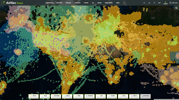
AirNav Systems has coverage only in areas where a feeder volunteer has installed one of our ADS-B receivers or shares data with a Raspberry Pi or Plane Plotter. However, with new feeders added every day, our network is growing fast. To view our coverage map click the link below. The legend indicates the various data sources that AirNav aggregates flight data from. They are briefly explained below.
https://www.airnavradar.com/coverage-map